Share
Sponsor – DOE
This task involves hydrological modeling related to water, sediment, mercury and tin in Tims Branch at Savannah River Site (SRS) which has been impacted by 60 years of anthropogenic events associated with discharges from process and laboratory facilities. Tims Branch provides a unique opportunity to study complex systems science in a full-scale ecosystem that experienced controlled step changes in boundary conditions.
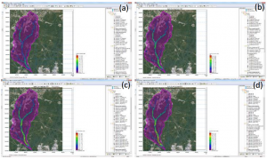
Fig 1. MIKE SHE simulation results of seasonal overland depth of water for the year 1993 indicating (a) spring, (b) summer, (c) fall, and (d) winter, overland flow simulations
FIU is continuing development and testing of an integrated hydrology and transport model of Tims Branch watershed using the MIKE commercial software suite developed by the Danish Hydraulic Institute (DHI) that is capable of simulating surface and subsurface hydrology and transport mechanisms. The Tims Branch watershed model was developed for a relatively well defined system in which all of the local mercury inputs were effectively eliminated via two remediation actions (2000 and 2007).
Furthermore, discharge of inorganic tin (as small micro particles and nanoparticles) was initiated in 2007 as a step function with high quality records on the quantity and timing of the release.
The principal objectives are to apply GIS and stream/ecosystem modeling tools to examine the response of Tims Branch to historical discharges and environmental management remediation actions.
Benefits:
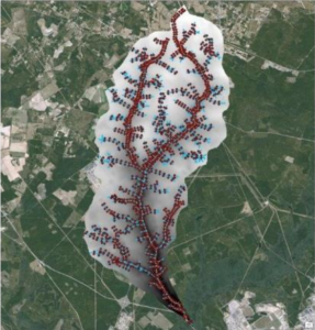
Fig 2. Cross sections of streams and tributaries in Tims Branch watershed that are directly exported from ArcGIS into MIKE 11
Accomplishments:
If you have a comment, we want to know.
Applied Research Center at
Florida International
University
10555 W. Flagler Street
Suite 2100
Miami, FL 33174
Tel: 305-348-4238
Fax:
305-348-1852
M-F (8:30 am to 5:00 pm)