Share
ARC-FIU researchers have developed a geodatabase to support the hydrological work being performed at at Oak Ridge Reservation (ORR), TN, which serves as a centralized data management system, making the large amounts of data generated from the simulations of contaminant fate and transport accessible to all users. The geodatabase facilitates storage, concurrent editing and import/export of model configuration and output data that is specific to the hydrologic models being used.
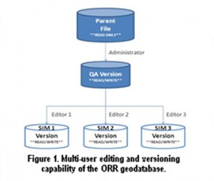
Multi-user editing and versioning capability of the ORR geodatabase
Benefits of this project include:
The ArcGIS geodatabase is an XML-based GIS data exchange system which facilitates the export and import of preconfigured data as XML files which can contain both the data definition and the data itself.

If you have a comment, we want to know.
Applied Research Center at
Florida International
University
10555 W. Flagler Street
Suite 2100
Miami, FL 33174
Tel: 305-348-4238
Fax:
305-348-1852
M-F (8:30 am to 5:00 pm)